World War II Illustrated AtlasAuthor :
Hardback
Published : Saturday 14 October 2023
Description
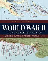
With 160 colour maps, World War II Illustrated Atlas plots the course of the land, sea and air campaigns in fine detail, tracing the ebb and flow of the fortunes of both sides. Contents include the land, sea and air campaigns in North-West Europe, Italy, North Africa, Russia, South-East Asia and the Pacific, Atlantic, and Mediterranean.
You may also like ...
by
Hardback
14 Oct 2023
Historical maps and atlases
€29.24
Extended stock – Dispatch 5-7 days
by
Paperback
15 Jun 2000
Curriculum planning and development
€57.32
Extended stock – Dispatch 5-7 days
by
Hardback
15 Jun 2000
Curriculum planning and development
€152.10
Extended stock – Dispatch 5-7 days

by
Paperback
15 Feb 2014
Literary essays
€25.74
Extended stock – Dispatch 5-7 days
Reviews